Updates

11.03.21 Drive to Denver

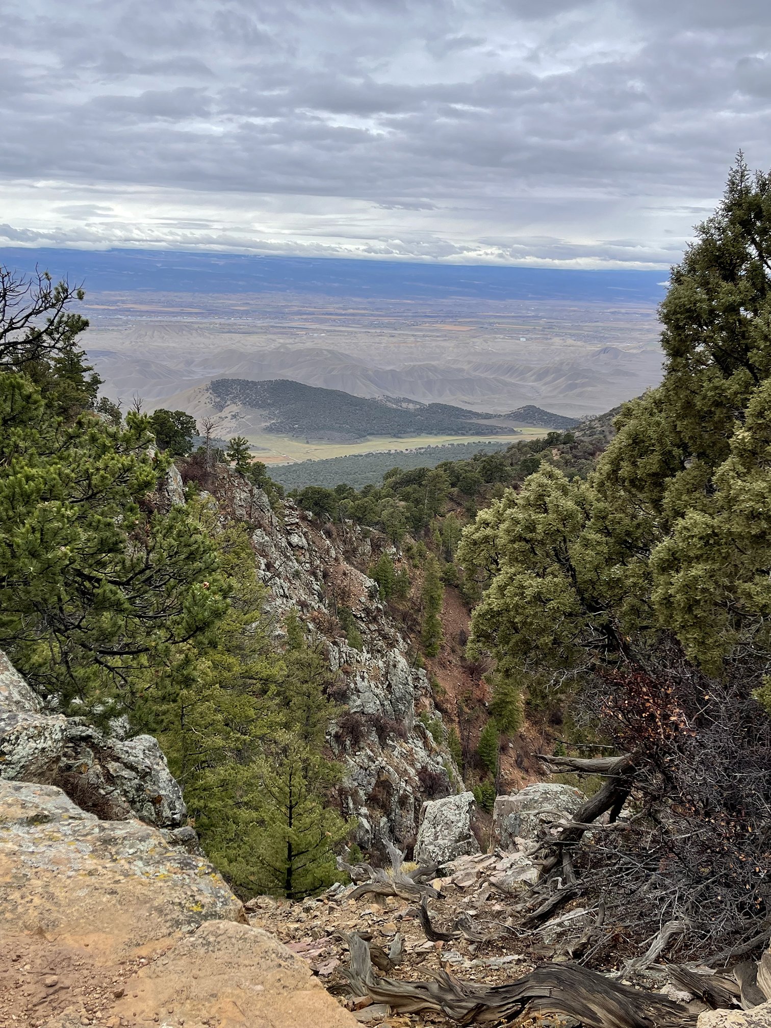
©11.03.21 Drive to Denver - View on way back to highway (CO92)

©11.03.21 Drive to Denver - View on way back to highway (CO92)

©11.03.21 Drive to Denver - View on way back to highway (CO92)
©11.03.21 Drive to Denver - View on way back to highway (CO92)

©11.03.21 Drive to Denver - View on back towards the Black Canyon from CO92

©11.03.21 Drive to Denver - Near Pioneer Point on CO9

©11.03.21 Drive to Denver - East end of Blue Mesa Reservoir which is really just the Gunnison River in this area. There is not enough water for the reservoir to be a lake here.

©11.03.21 Drive to Denver - East end of Blue Mesa Reservoir which is really just the Gunnison River in this area.

©11.03.21 Drive to Denver - My third time over the Continental Divide on this trip so far. The other 2 times were just a blip in the road in New Mexico.

©11.03.21 Drive to Denver - View from Monarch Pass

©11.03.21 Drive to Denver - View from Monarch Pass

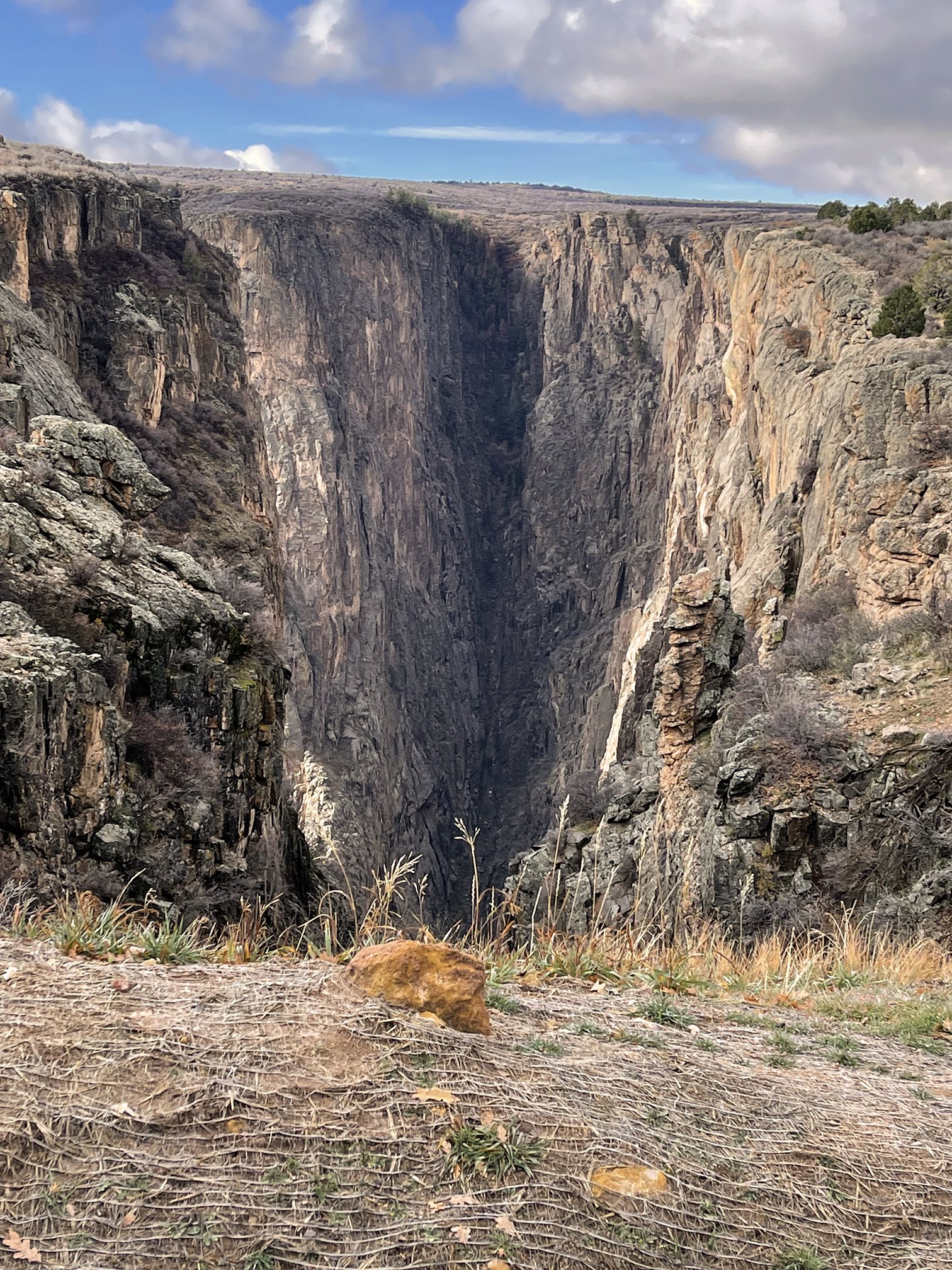
11.03.21 Black Canyon of the Gunnison - North Rim - Pt. 3

©11.03.21 Black Canyon of the Gunnison - North Rim - Big Island Viewpoint

©11.03.21 Black Canyon of the Gunnison - North Rim - Big Island Viewpoint

©11.03.21 Black Canyon of the Gunnison - North Rim - Big Island Viewpoint

©11.03.21 Black Canyon of the Gunnison - North Rim - Big Island Viewpoint

©11.03.21 Black Canyon of the Gunnison - North Rim - Big Island Viewpoint

©11.03.21 Black Canyon of the Gunnison - North Rim - Big Island Viewpoint

©11.03.21 Black Canyon of the Gunnison - North Rim - Big Island Viewpoint

©11.03.21 Black Canyon of the Gunnison - North Rim - Big Island Viewpoint

©11.03.21 Black Canyon of the Gunnison - North Rim - Big Island Viewpoint

©11.03.21 Black Canyon of the Gunnison - North Rim Road View
©11.03.21 Black Canyon of the Gunnison - North Rim Road view

©11.03.21 Black Canyon of the Gunnison - North Rim - Balanced Rock Viewpoint - Looking back towards the road and the spot I took the photo above.

©11.03.21 Black Canyon of the Gunnison - North Rim - Balanced Rock Viewpoint

©11.03.21 Black Canyon of the Gunnison - North Rim - Balanced Rock Viewpoint

©11.03.21 Black Canyon of the Gunnison - North Rim - Balanced Rock Viewpoint

©11.03.21 Black Canyon of the Gunnison - North Rim - Balanced Rock Viewpoint

©11.03.21 Black Canyon of the Gunnison - North Rim - Balanced Rock Viewpoint

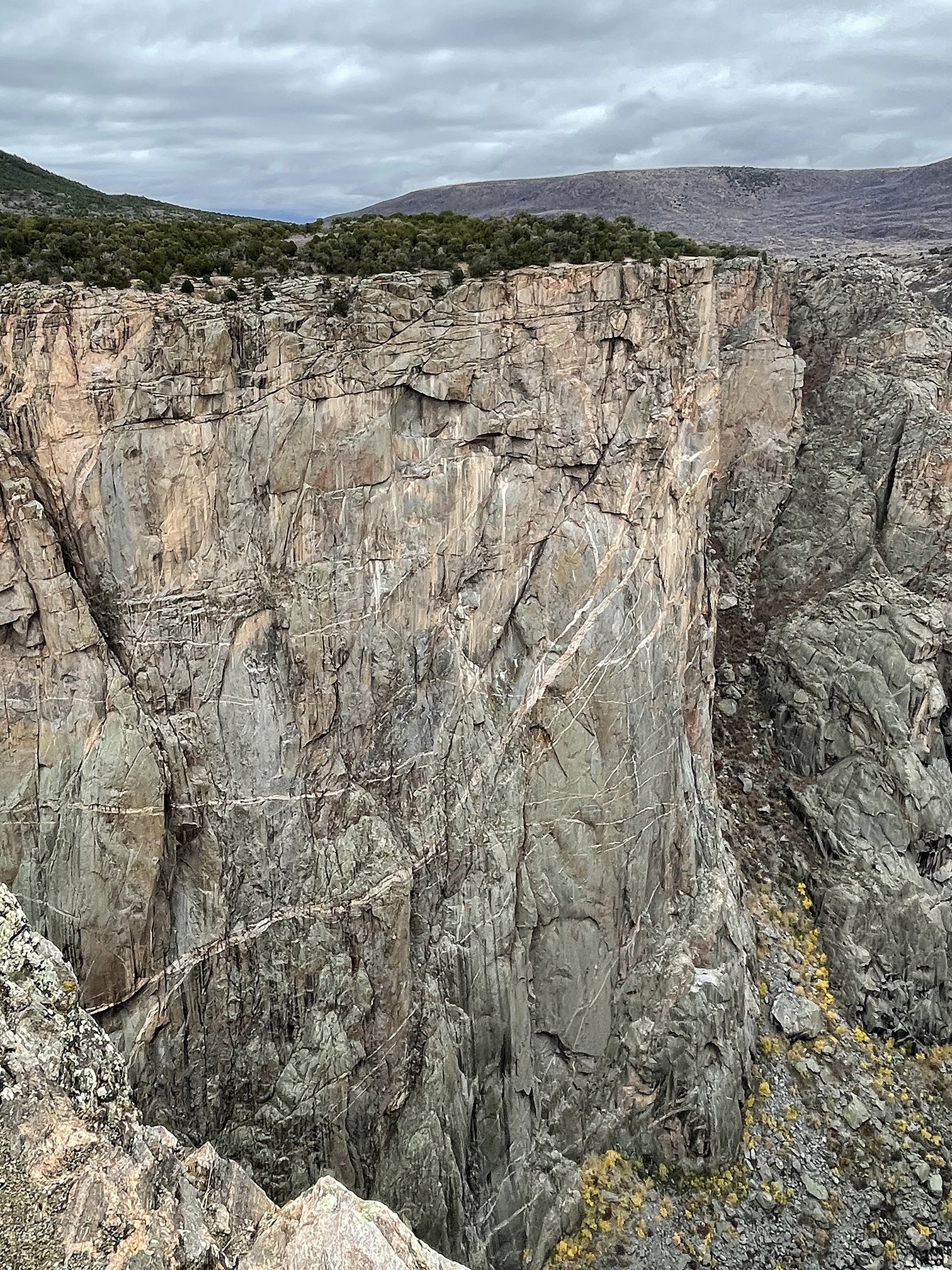
©11.03.21 Black Canyon of the Gunnison - North Rim - The Narrows Viewpoint

©11.03.21 Black Canyon of the Gunnison - North Rim - The Narrows Viewpoint

©11.03.21 Black Canyon of the Gunnison - North Rim - The Narrows Viewpoint

©11.03.21 Black Canyon of the Gunnison - North Rim - The Narrows Viewpoint

©11.03.21 Black Canyon of the Gunnison - North Rim - The Narrows Viewpoint

©11.03.21 Black Canyon of the Gunnison - North Rim - The Narrows Viewpoint

©11.03.21 Black Canyon of the Gunnison - North Rim - The Narrows Viewpoint

©11.03.21 Black Canyon of the Gunnison - North Rim - The Narrows Viewpoint

©11.03.21 Black Canyon of the Gunnison - North Rim - The Narrows Viewpoint

©11.03.21 Black Canyon of the Gunnison - North Rim - The Narrows Viewpoint
©11.03.21 Black Canyon of the Gunnison - North Rim - Drive out of the park

©11.03.21 Black Canyon of the Gunnison - North Rim Sky

11.03.21 Black Canyon of the Gunnison - North Rim - Pt. 2

©11.03.21 Black Canyon of the Gunnison - North Rim Road - This road is not for the faint of heart. Yes the canyon really does drop off right next to the road in several spots.

©11.03.21 Black Canyon of the Gunnison - North Rim Road

©11.03.21 Black Canyon of the Gunnison - North Rim - Kneeling Camel Viewpoint

©11.03.21 Black Canyon of the Gunnison - North Rim - Kneeling Camel Viewpoint

©11.03.21 Black Canyon of the Gunnison - North Rim - Kneeling Camel Viewpoint

©11.03.21 Black Canyon of the Gunnison - North Rim - Kneeling Camel Viewpoint

©11.03.21 Black Canyon of the Gunnison - North Rim - Kneeling Camel Viewpoint

©11.03.21 Black Canyon of the Gunnison - North Rim - Kneeling Camel Viewpoint

©11.03.21 Black Canyon of the Gunnison - North Rim - Kneeling Camel Viewpoint

©11.03.21 Black Canyon of the Gunnison - North Rim - Kneeling Camel Viewpoint

©11.03.21 Black Canyon of the Gunnison - North Rim - Island Peaks Viewpoint

©11.03.21 Black Canyon of the Gunnison - North Rim - Island Peaks Viewpoint

©11.03.21 Black Canyon of the Gunnison - North Rim - Island Peaks Viewpoint

©11.03.21 Black Canyon of the Gunnison - North Rim - Island Peaks Viewpoint

©11.03.21 Black Canyon of the Gunnison - North Rim - Island Peaks Viewpoint
©11.03.21 Black Canyon of the Gunnison - North Rim - Island Peaks Viewpoint

©11.03.21 Black Canyon of the Gunnison - North Rim - Island Peaks Viewpoint

©11.03.21 Black Canyon of the Gunnison - North Rim - Island Peaks Viewpoint

©11.03.21 Black Canyon of the Gunnison - North Rim - Island Peaks Viewpoint

©11.03.21 Black Canyon of the Gunnison - North Rim - Island Peaks Viewpoint

©11.03.21 Black Canyon of the Gunnison - North Rim - Island Peaks Viewpoint

©11.03.21 Black Canyon of the Gunnison - North Rim - Another spot along the road that drops off dramatically.

11.03.21 Black Canyon of the Gunnison NP - North Rim - Pt. 1

©11.03.21 Black Canyon of the Gunnison - North Rim - The sign on this side of the canyon is not as fancy and is more difficult to get to.

©11.03.21 Black Canyon of the Gunnison - North Rim - View looking back towards the highway (CO92)

©11.03.21 Black Canyon of the Gunnison - North Rim - View into the park

©11.03.21 Black Canyon of the Gunnison - North Rim - First glimpse of the canyon from this side

©11.03.21 Black Canyon of the Gunnison - North Rim Road - Another foggy morning

©11.03.21 Black Canyon of the Gunnison - North Rim Road end

©11.03.21 Black Canyon of the Gunnison - North Rim Road end view

©11.03.21 Black Canyon of the Gunnison - North Rim Road end view

©11.03.21 Black Canyon of the Gunnison - North Rim Road end view of Kneeling Camel Overlook

©11.03.21 Black Canyon of the Gunnison - North Rim Road end view of South Rim Visitor Center
©11.03.21 Black Canyon of the Gunnison - North Rim Road end view

©11.03.21 Black Canyon of the Gunnison - North Rim Road end view

©11.03.21 Black Canyon of the Gunnison - North Rim Road end view

©11.03.21 Black Canyon of the Gunnison - North Rim Road end view

©11.03.21 Black Canyon of the Gunnison - North Rim Road end

©11.03.21 Black Canyon of the Gunnison - North Rim Road end view

11.03.21 Drive to Black Canyon of the Gunnison - North Rim

©11.03.21 Drive to Black Canyon of the Gunnison - North Rim - Drove along back county roads on my way to the North Rim as the sun was rising

©11.03.21 Drive to Black Canyon of the Gunnison - North Rim

©11.03.21 Drive to Black Canyon of the Gunnison - North Rim - morning fog
©11.03.21 Drive to Black Canyon of the Gunnison - North Rim - morning fog

©11.03.21 Drive to Black Canyon of the Gunnison - North Rim - morning fog

©11.03.21 Drive to Black Canyon of the Gunnison - North Rim - morning fog outside Crawford

©11.03.21 Drive to Black Canyon of the Gunnison - North Rim - View across Crawford State Park after turning off the highway on the way to the park.

©11.03.21 Drive to Black Canyon of the Gunnison - North Rim - View across Crawford State Park after turning off the highway on the way to the park.

11.02.21 Black Canyon of the Gunnison - Pt. 6

©11.02.21 Black Canyon of the Gunnison - Rock Point Overlook

©11.02.21 Black Canyon of the Gunnison - Rock Point Overlook

©11.02.21 Black Canyon of the Gunnison - Rock Point Overlook Trail

©11.02.21 Black Canyon of the Gunnison - Rock Point Overlook

©11.02.21 Black Canyon of the Gunnison - Rock Point Overlook

©11.02.21 Black Canyon of the Gunnison - Rock Point Overlook

©11.02.21 Black Canyon of the Gunnison - Rock Point Overlook

©11.02.21 Black Canyon of the Gunnison - Rock Point Overlook

©11.02.21 Black Canyon of the Gunnison - Rock Point Overlook
©11.02.21 Black Canyon of the Gunnison - Rock Point Overlook

©11.02.21 Black Canyon of the Gunnison - Rock Point Overlook

©11.02.21 Black Canyon of the Gunnison - Rock Point Overlook

©11.02.21 Black Canyon of the Gunnison - Cross Fissures Overlook

©11.02.21 Black Canyon of the Gunnison - Cross Fissures Overlook

©11.02.21 Black Canyon of the Gunnison - Cross Fissures Overlook

©11.02.21 Black Canyon of the Gunnison - Cross Fissures Overlook

©11.02.21 Black Canyon of the Gunnison - Pulpit Rock Overlook

©11.02.21 Black Canyon of the Gunnison - Pulpit Rock Overlook

©11.02.21 Black Canyon of the Gunnison - Pulpit Rock Overlook

©11.02.21 Black Canyon of the Gunnison - Pulpit Rock Overlook

©11.02.21 Black Canyon of the Gunnison - Tomichi Point Overlook

©11.02.21 Black Canyon of the Gunnison - Tomichi Point Overlook

©11.02.21 Black Canyon of the Gunnison - Entrance Sign - someone was parked here on my way in, so I took the photo on my way out.

©11.02.21 Black Canyon of the Gunnison - Rain showers in the distance seen on the drive back into Montrose

©11.02.21 Black Canyon of the Gunnison - Drive back into town

©11.02.21 Black Canyon of the Gunnison - Drive back into town

©11.02.21 Black Canyon of the Gunnison - Drive back into town

11.02.21 Black Canyon of the Gunnison - Pt. 5

©11.02.21 Black Canyon of the Gunnison - Devils Overlook
©11.02.21 Black Canyon of the Gunnison - Devils Overlook

©11.02.21 Black Canyon of the Gunnison - Devils Overlook - That’s the road I plan to take in the morning to explore the North Rim

©11.02.21 Black Canyon of the Gunnison - Devils Overlook

©11.02.21 Black Canyon of the Gunnison - Devils Overlook

©11.02.21 Black Canyon of the Gunnison - Devils Overlook

©11.02.21 Black Canyon of the Gunnison - Devils Overlook

©11.02.21 Black Canyon of the Gunnison - Devils Overlook

©11.02.21 Black Canyon of the Gunnison - Devils Overlook

©11.02.21 Black Canyon of the Gunnison - Devils Overlook

11.02.21 Black Canyon of the Gunnison - Pt. 4

©11.02.21 Black Canyon of the Gunnison - Cedar Point Overlook

©11.02.21 Black Canyon of the Gunnison - Cedar Point Overlook

©11.02.21 Black Canyon of the Gunnison - Cedar Point Overlook

©11.02.21 Black Canyon of the Gunnison - Cedar Point Overlook

©11.02.21 Black Canyon of the Gunnison - Cedar Point Overlook

©11.02.21 Black Canyon of the Gunnison - Cedar Point Overlook

©11.02.21 Black Canyon of the Gunnison - Cedar Point Overlook

©11.02.21 Black Canyon of the Gunnison - Cedar Point Overlook - view of Painted Wall

©11.02.21 Black Canyon of the Gunnison - Cedar Point Overlook

©11.02.21 Black Canyon of the Gunnison - Painted Wall View Overlook

©11.02.21 Black Canyon of the Gunnison - Painted Wall View Overlook - This sign gives a good sense of the height of the canyon walls.

©11.02.21 Black Canyon of the Gunnison - Painted Wall View

©11.02.21 Black Canyon of the Gunnison - Painted Wall View Overlook
©11.02.21 Black Canyon of the Gunnison - Painted Wall View

©11.02.21 Black Canyon of the Gunnison - Painted Wall View Overlook - peek-a-boo view of Painted Wall

©11.02.21 Black Canyon of the Gunnison - Chasm View Overlook - I think it says 7,761 ft

©11.02.21 Black Canyon of the Gunnison - Chasm View Overlook

©11.02.21 Black Canyon of the Gunnison - Chasm View Overlook

©11.02.21 Black Canyon of the Gunnison - Chasm View Overlook
©11.02.21 Black Canyon of the Gunnison - Chasm View Overlook

©11.02.21 Black Canyon of the Gunnison - Chasm View Overlook

11.02.21 Black Canyon of the Gunnison - Pt. 3

©11.02.21 Black Canyon of the Gunnison - Sunset View Overlook

©11.02.21 Black Canyon of the Gunnison - Sunset View Overlook

©11.02.21 Black Canyon of the Gunnison - Sunset View Overlook - This looking back towards Warner Point

©11.02.21 Black Canyon of the Gunnison - Sunset View Overlook
©11.02.21 Black Canyon of the Gunnison - Sunset View Overlook

©11.02.21 Black Canyon of the Gunnison - Sunset View Overlook

©11.02.21 Black Canyon of the Gunnison - Dragon Point Overlook

©11.02.21 Black Canyon of the Gunnison - Dragon Point Overlook - View of Serpent Point and part of the Painted Wall

©11.02.21 Black Canyon of the Gunnison - Dragon Point Overlook

©11.02.21 Black Canyon of the Gunnison - Dragon Point Overlook

©11.02.21 Black Canyon of the Gunnison - Dragon Point Overlook

©11.02.21 Black Canyon of the Gunnison - Dragon Point Overlook

©11.02.21 Black Canyon of the Gunnison - Dragon Point Overlook

©11.02.21 Black Canyon of the Gunnison - Dragon Point Overlook

©11.02.21 Black Canyon of the Gunnison - Dragon Point Overlook

©11.02.21 Black Canyon of the Gunnison - Dragon Point Overlook

11.02.21 Black Canyon of the Gunnison NP - Pt. 2

©11.02.21 Black Canyon of the Gunnison - Warner Point Trail - Headed to the end of the South Rim Trail road to start and then worked my way back to the Visitor Center

©11.02.21 Black Canyon of the Gunnison - Warner Point Trail - one side of the trail looks down over the valley and the city of Montrose

©11.02.21 Black Canyon of the Gunnison - Warner Point Trail

©11.02.21 Black Canyon of the Gunnison - Warner Point Trail - The other side of the trail looks into the Canyon - which was not very visible on the hike out.

©11.02.21 Black Canyon of the Gunnison - Warner Point Trail

©11.02.21 Black Canyon of the Gunnison - Warner Point Trail

©11.02.21 Black Canyon of the Gunnison - Warner Point Trail

©11.02.21 Black Canyon of the Gunnison - Warner Point Trail

©11.02.21 Black Canyon of the Gunnison - Warner Point Trail

©11.02.21 Black Canyon of the Gunnison - Warner Point view
©11.02.21 Black Canyon of the Gunnison - Warner Point view

©11.02.21 Black Canyon of the Gunnison - Warner Point view

©11.02.21 Black Canyon of the Gunnison - Warner Point view
©11.02.21 Black Canyon of the Gunnison - Warner Point view

©11.02.21 Black Canyon of the Gunnison - Warner Point view

©11.02.21 Black Canyon of the Gunnison - Warner Point view

©11.02.21 Black Canyon of the Gunnison - Warner Point view

©11.02.21 Black Canyon of the Gunnison - Warner Point

©11.02.21 Black Canyon of the Gunnison - Warner Point Trail - The view into the canyon cleared up on the way back to the car

©11.02.21 Black Canyon of the Gunnison - Warner Point Trail

©11.02.21 Black Canyon of the Gunnison - Warner Point Trail

11.02.21 Black Canyon of the Gunnison NP - Pt.1

©11.02.21 Black Canyon of the Gunnison - Arrived to low lying fog over the canyon and a light rain

©11.02.21 Black Canyon of the Gunnison - Visitor Center Overlook

©11.02.21 Black Canyon of the Gunnison - When you arrive at the park and it’s foggy, you hope for the clouds will lift and you will be able to see something soon.

©11.02.21 Black Canyon of the Gunnison - Visitor Center Overlook

©11.02.21 Black Canyon of the Gunnison - View of Gunnison Point

©11.02.21 Black Canyon of the Gunnison - Gunnison Point view

©11.02.21 Black Canyon of the Gunnison - Gunnison Point view

©11.02.21 Black Canyon of the Gunnison - Gunnison Point view

©11.02.21 Black Canyon of the Gunnison - Gunnison Point view

©11.02.21 Black Canyon of the Gunnison - Gunnison Point view
©11.02.21 Black Canyon of the Gunnison - Gunnison Point view

©11.02.21 Black Canyon of the Gunnison - Gunnison Point view

©11.02.21 Black Canyon of the Gunnison - Gunnison Point view of Visitor Center

©11.02.21 Black Canyon of the Gunnison - Gunnison Point view

©11.02.21 Black Canyon of the Gunnison - Gunnison Point

©11.02.21 Black Canyon of the Gunnison - Gunnison Point view

©11.02.21 Black Canyon of the Gunnison - Gunnison Point

©11.02.21 Black Canyon of the Gunnison - Gunnison Point view

©11.02.21 Black Canyon of the Gunnison - Gunnison Point view

11.01.21 Drive from Cortez to Montrose - Pt. 2

©11.01.21 Drive from Cortez to Montrose - Looking back the way I came from Silverton

©11.01.21 Drive from Cortez to Montrose - Red Mountain Pass

©11.01.21 Drive from Cortez to Montrose - View from Red Mountain Pass

©11.01.21 Drive from Cortez to Montrose - View from Red Mountain Pass

©11.01.21 Drive from Cortez to Montrose - View on the road down from Red Mountain Pass

©11.01.21 Drive from Cortez to Montrose - View on the road down from Red Mountain Pass - Yes, the road really is that twisty

©11.01.21 Drive from Cortez to Montrose - View on the road down from Red Mountain Pass

©11.01.21 Drive from Cortez to Montrose - View on the road down from Red Mountain Pass

©11.01.21 Drive from Cortez to Montrose - View on the road down from Red Mountain Pass

©11.01.21 Drive from Cortez to Montrose - View on the road down from Red Mountain Pass

©11.01.21 Drive from Cortez to Montrose - Red Mountain Creek

©11.01.21 Drive from Cortez to Montrose - Red Mountain Creek

©11.01.21 Drive from Cortez to Montrose - Red Mountain Creek

©11.01.21 Drive from Cortez to Montrose - Crystal Lake
©11.01.21 Drive from Cortez to Montrose - Crystal Lake looking towards Red Mountain

©11.01.21 Drive from Cortez to Montrose - Red Mountain Creek

©11.01.21 Drive from Cortez to Montrose - View from Bear Creek Falls Overlook

©11.01.21 Drive from Cortez to Montrose - View from Bear Creek Falls Overlook

©11.01.21 Drive from Cortez to Montrose - View from Bear Creek Falls Overlook

©11.01.21 Drive from Cortez to Montrose - View from Bear Creek Falls Overlook, Uncompahgre River

©11.01.21 Drive from Cortez to Montrose - View of Bear Creek Falls

©11.01.21 Drive from Cortez to Montrose - View from Bear Creek Falls Overlook

©11.01.21 Drive from Cortez to Montrose - View from Bear Creek below the Falls

©11.01.21 Drive from Cortez to Montrose - Bear Creek Falls Tunnel

©11.01.21 Drive from Cortez to Montrose - View from Ridgeway of the mountains I just drove through

©11.01.21 Drive from Cortez to Montrose - View from Ridgeway of the mountains I just drove through

©11.01.21 Drive from Cortez to Montrose - View from Ridgeway of the mountains I just drove through

©11.01.21 Drive from Cortez to Montrose - View from Ridgeway of the mountains I just drove through

©11.01.21 Drive from Cortez to Montrose - View from Ridgeway of the mountains to the east

©11.01.21 Drive from Cortez to Montrose - View from Ridgeway of the mountains to the east

©11.01.21 Drive from Cortez to Montrose - View from Ridgeway of the mountains I just drove through

©11.01.21 Drive from Cortez to Montrose - McDonald’s sign in Montrose

11.01.21 Drive from Cortez to Montrose over the Million Dollar Highway, Pt. 1

©11.01.21 Drive from Cortez to Montrose - Near Lake Purgatory

©11.01.21 Drive from Cortez to Montrose - Near Lake Purgatory

©11.01.21 Drive from Cortez to Montrose - Engineer’s Peak

©11.01.21 Drive from Cortez to Montrose

©11.01.21 Drive from Cortez to Montrose - Beginning of Million Dollar Highway

©11.01.21 Drive from Cortez to Montrose - View from Million Dollar Highway

©11.01.21 Drive from Cortez to Montrose - View from Million Dollar Highway

©11.01.21 Drive from Cortez to Montrose - View from Molas Pass , 10,910 ft elevation

©11.01.21 Drive from Cortez to Montrose - View from Molas Pass

©11.01.21 Drive from Cortez to Montrose - View from Molas Pass

©11.01.21 Drive from Cortez to Montrose - View from Molas Pass

©11.01.21 Drive from Cortez to Montrose - View from Molas Pass

©11.01.21 Drive from Cortez to Montrose - View from Molas Pass
©11.01.21 Drive from Cortez to Montrose - View from Molas Pass

©11.01.21 Drive from Cortez to Montrose - View from Molas Pass

©11.01.21 Drive from Cortez to Montrose - View from Molas Pass

©11.01.21 Drive from Cortez to Montrose - View from Molas Pass

©11.01.21 Drive from Cortez to Montrose - View from Molas Pass

©11.01.21 Drive from Cortez to Montrose - View from Molas Pass

©11.01.21 Drive from Cortez to Montrose - View from Molas Pass

10.31.21 Mesa Verde - Pt. 6

©10.31.21 Mesa Verde - Cedar Tree Tower

©10.31.21 Mesa Verde - Cedar Tree Tower

©10.31.21 Mesa Verde - Cedar Tree Tower

©10.31.21 Mesa Verde - Cedar Tree Tower

©10.31.21 Mesa Verde - Far View House

©10.31.21 Mesa Verde - Far View House

©10.31.21 Mesa Verde - Far View House

©10.31.21 Mesa Verde - Pipe Shrine House

©10.31.21 Mesa Verde - Pipe Shrine House

©10.31.21 Mesa Verde - Coyote Village

©10.31.21 Mesa Verde - Coyote Village

©10.31.21 Mesa Verde - Coyote Village

©10.31.21 Mesa Verde - Coyote Village

©10.31.21 Mesa Verde - Coyote Village

©10.31.21 Mesa Verde - Along the trail to Far View Reservoir
©10.31.21 Mesa Verde - Far View Reservoir

©10.31.21 Mesa Verde - Far View Reservoir

©10.31.21 Mesa Verde - Far View Reservoir

©10.31.21 Mesa Verde - Far View Reservoir

©10.31.21 Mesa Verde - Megalithic House

©10.31.21 Mesa Verde - Far View Site

©10.31.21 Mesa Verde - View on drive out of the park

©10.31.21 Mesa Verde - View on drive out of the park

©10.31.21 Mesa Verde - View on drive out of the park

©10.31.21 Mesa Verde - View on drive out of the park

10.31.21 Mesa Verde - Pt. 5

©10.31.21 Mesa Verde - Oak Tree House Overlook AD 1250

©10.31.21 Mesa Verde - Oak Tree House Overlook AD 1250 - View of Sun Temple above

©10.31.21 Mesa Verde - Fire Temple Overlook AD 1250

©10.31.21 Mesa Verde - View from Fire Temple Overlook AD 1250

©10.31.21 Mesa Verde - View from Fire Temple Overlook AD 1250

©10.31.21 Mesa Verde - Sun Temple AD 1250
©10.31.21 Mesa Verde - Clouds above Sun Temple, AD 1250

©10.31.21 Mesa Verde - View from the Sun Temple AD 1250

©10.31.21 Mesa Verde - Sun Temple AD 1250

©10.31.21 Mesa Verde - Sun Temple AD 1250

©10.31.21 Mesa Verde - View from the Sun Temple AD 1250

©10.31.21 Mesa Verde - near the Sun Temple AD 1250

©10.31.21 Mesa Verde - view from the Sun Temple AD 1250

©10.31.21 Mesa Verde - Cliff Palace from the Sun Temple AD 1250

©10.31.21 Mesa Verde - Cliff Palace from the Sun Temple AD 1250

©10.31.21 Mesa Verde - Near the Sun Temple AD 1250

©10.31.21 Mesa Verde - Cliff Palace Overlook

©10.31.21 Mesa Verde - Cliff Palace Overlook

©10.31.21 Mesa Verde - Chapin Mesa

©10.31.21 Mesa Verde - Chapin Mesa

10.31.21 Mesa Verde - Pt. 4

©10.31.21 Mesa Verde - Navajo Canyon View on Chapin Mesa

©10.31.21 Mesa Verde - Navajo Canyon View on Chapin Mesa
©10.31.21 Mesa Verde - Square Tower Overlook on Chapin Mesa

©10.31.21 Mesa Verde - Square Tower Overlook on Chapin Mesa

©10.31.21 Mesa Verde - Square Tower Overlook on Chapin Mesa

©10.31.21 Mesa Verde - Pit houses and pueblos AD 700-950

©10.31.21 Mesa Verde - Pit houses and pueblos AD 700-950

©10.31.21 Mesa Verde - Mesa Top Sites AD 900 -1100

©10.31.21 Mesa Verde - Mesa Top Sites AD 900 -1100

©10.31.21 Mesa Verde - Mesa Top Sites AD 900 -1100

©10.31.21 Mesa Verde - Mesa Top Sites AD 900 -1100

©10.31.21 Mesa Verde - Mesa Top Sites AD 900 -1100

©10.31.21 Mesa Verde - Mesa Top Sites AD 900 -1100

©10.31.21 Mesa Verde - Mesa Top Sites AD 900 -1100

©10.31.21 Mesa Verde - Sun Point View Overlook AD 1200-1300

©10.31.21 Mesa Verde - Sun Point View Overlook AD 1200-1300

©10.31.21 Mesa Verde - Sun Point View Overlook AD 1200-1300

©10.31.21 Mesa Verde - Sun Point View Overlook AD 1200-1300

10.31.21 Mesa Verde - Pt. 3

©10.31.21 Mesa Verde - View on hike to Long House on Wetherill Mesa, seen near the Badger House Community

©10.31.21 Mesa Verde - Basketmaker Pithouses at Badger House Community

©10.31.21 Mesa Verde - View on hike to Long House on Wetherill Mesa

©10.31.21 Mesa Verde - View on hike to Long House on Wetherill Mesa

©10.31.21 Mesa Verde - View on hike to Long House on Wetherill Mesa

©10.31.21 Mesa Verde - Pueblo Village at Badger House Community

©10.31.21 Mesa Verde - Pueblo Village at Badger House Community

©10.31.21 Mesa Verde - View on hike to Long House on Wetherill Mesa
©10.31.21 Mesa Verde - Long House Overlook on Wetherill Mesa

©10.31.21 Mesa Verde - Long House Overlook on Wetherill Mesa - To give you a sense of scale, do you see the white box in the lower left corner? I’m pretty sure that is the size of a small container box.

©10.31.21 Mesa Verde - Long House Overlook on Wetherill Mesa

©10.31.21 Mesa Verde - Long House Overlook on Wetherill Mesa, view of Wildhorse Mesa

©10.31.21 Mesa Verde - Long House Overlook on Wetherill Mesa

©10.31.21 Mesa Verde - Long House Overlook on Wetherill Mesa

©10.31.21 Mesa Verde - Long House Overlook on Wetherill Mesa

©10.31.21 Mesa Verde - View on hike back to the car on Wetherill Mesa

©10.31.21 Mesa Verde - View on hike back to the car on Wetherill Mesa

©10.31.21 Mesa Verde - View on hike back to the car on Wetherill Mesa

©10.31.21 Mesa Verde - I almost stepped on this guy. Probably would have if I didn’t see it move out of the corner of my eye.

10.31.21 Mesa Verde - Pt. 2

©10.31.21 Mesa Verde - Park Point Overlook

©10.31.21 Mesa Verde - Park Point Overlook

©10.31.21 Mesa Verde - Park Point Overlook

©10.31.21 Mesa Verde - View south from Park Point Overlook

©10.31.21 Mesa Verde - Hazy view of Shiprock to the south at Park Point Overlook

©10.31.21 Mesa Verde - View northeast at Park Point Overlook

©10.31.21 Mesa Verde - View north at Park Point Overlook
©10.31.21 Mesa Verde - View north from Park Point Overlook

©10.31.21 Mesa Verde - View east from Park Point Overlook, including the road thru the park

©10.31.21 Mesa Verde - View to the northwest from Park Point Overlook

©10.31.21 Mesa Verde - 1934 surveyors mark at Park Point Overlook

©10.31.21 Mesa Verde - I hit 11,111 miles on my car shortly after leaving Park Point Overlook

©10.31.21 Mesa Verde - View along the road from Park Point Overlook

©10.31.21 Mesa Verde - Wild horse seen on drive out to Wetherill Mesa

©10.31.21 Mesa Verde - View on hike to Long House on Wetherill Mesa. This was the last day the mesa was open for the year.

©10.31.21 Mesa Verde - View on hike to Long House on Wetherill Mesa

©10.31.21 Mesa Verde - View on hike to Long House on Wetherill Mesa

©10.31.21 Mesa Verde - View on hike to Long House on Wetherill Mesa

10.31.21 Mesa Verde - Pt. 1

©10.31.21 Mesa Verde - Park Entrance

©10.31.21 Mesa Verde - Hesperus Mountains

©10.31.21 Mesa Verde - Visitor Center

©10.31.21 Mesa Verde - View of mesa from visitor center

©10.31.21 Mesa Verde - View of mesa from Park Entrance

©10.31.21 Mesa Verde

©10.31.21 Mesa Verde - View from Mancos Valley Overlook

©10.31.21 Mesa Verde - View from Mancos Valley Overlook

©10.31.21 Mesa Verde - View from Mancos Valley Overlook

©10.31.21 Mesa Verde - View from Montezuma Valley Overlook

©10.31.21 Mesa Verde - View of Sleeping Ute Mountain from Montezuma Valley Overlook

©10.31.21 Mesa Verde - View of the Knife Edge from Montezuma Valley Overlook

©10.31.21 Mesa Verde - View of the Knife Edge from Montezuma Valley Overlook

©10.31.21 Mesa Verde - View from Montezuma Valley Overlook

©10.31.21 Mesa Verde - View from Montezuma Valley Overlook

©10.31.21 Mesa Verde - View along the road to Park Point Overlook

©10.31.21 Mesa Verde - View along the road to Park Point Overlook

©10.31.21 Mesa Verde - View along the road to Park Point Overlook

©10.31.21 Mesa Verde - View along the road to Park Point Overlook
©10.31.21 Mesa Verde - View along the road to Park Point Overlook

10.30.21 Los Alamos, NM to Cortez, CO

©10.30.21 Los Alamos to Cortez - Abiquiu Lake

©10.30.21 Los Alamos to Cortez - near Abiquiu Lake

©10.30.21 Los Alamos to Cortez - Somewhere along NM96

©10.30.21 Los Alamos to Cortez - Farmington, NM

©10.30.21 Los Alamos to Cortez - Farmington, NM

©10.30.21 Los Alamos to Cortez - Farmington, NM

©10.30.21 Los Alamos to Cortez - Four Corners

©10.30.21 Los Alamos to Cortez - Four Corners

©10.30.21 Los Alamos to Cortez - Utah (left) and Colorado (right)

©10.30.21 Los Alamos to Cortez - Colorado

©10.30.21 Los Alamos to Cortez - Four Corners

©10.30.21 Los Alamos to Cortez - Wild horses at Four Corners
©10.30.21 Los Alamos to Cortez - Four Corners

©10.30.21 Los Alamos to Cortez - It’s good to be back

©10.30.21 Los Alamos to Cortez - Shiprock from Colorado

©10.30.21 Los Alamos to Cortez - Chimney Rock

©10.30.21 Los Alamos to Cortez - Chimney Rock

©10.30.21 Los Alamos to Cortez - Cork’n Bottle